2007 Trip to Nevada, Utah and Arizona

Capitol Reef National Park

Friday  2007-03-09  SR29, Utah  We have a late lunch at Ruby's Inn near the park entrance and head for Torrey at the entrance to Capitol Reef NP.
Friday 2007-03-09 SR29, Utah
We have a late lunch at Ruby's Inn near the park entrance and head for Torrey at the entrance to Capitol Reef NP.
Friday  2007-03-09  SR29, Utah  We head east through two small towns on our way to Escalante.
Friday 2007-03-09 SR29, Utah
We head east through two small towns on our way to Escalante.
We drive through Escalante and 10 Miles north we pull into this scenic lookout.
Sign at the lookout. The mountains are named after Joseph Henry, the first secretary of the Smithsonian Institution.
Friday  2007-03-09  SR29, Utah  The  Henry Mountains, at 11,500 ft,  are 75 kms away in the distance. They are with us for the rest of the day and for a couple of hours tomorrow.
Friday 2007-03-09 SR29, Utah
The Henry Mountains, at 11,500 ft, are 75 kms away in the distance. They are with us for the rest of the day and for a couple of hours tomorrow.
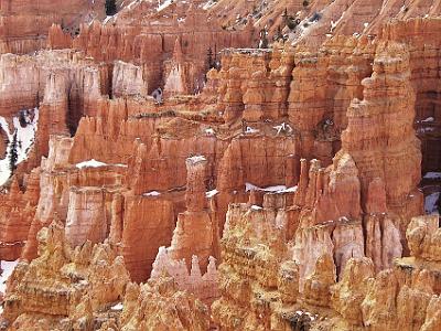
SR29 winds its way along the valley floor, still at about 6000 ft. We've dropped down from 9100 feet in the Bryce Canyon NP.
Friday  2007-03-09  SR29, Utah  The area is one of the most desolate in the USA. The scenery is spectacular.
Friday 2007-03-09 SR29, Utah
The area is one of the most desolate in the USA. The scenery is spectacular.
Friday  2007-03-09  SR29, Utah  The panorama from the lookout.
Friday 2007-03-09 SR29, Utah
The panorama from the lookout.
The road is a bit dangerous in places and low speeds are in order.
This is one of the most beautiful, lonely, drives we've ever taken.
Friday  2007-03-09  SR29, Utah  Boulder Mountain makes up half of the   Aquarius Plateau  . The mountain rises to the west of Capitol Reef National Park and has over 50,000 acres  of rolling forest and meadowlands on its top.  It is the highest timbered plateau in North America and is part of the Dixie National Forest
Friday 2007-03-09 SR29, Utah
Boulder Mountain makes up half of the Aquarius Plateau. The mountain rises to the west of Capitol Reef National Park and has over 50,000 acres of rolling forest and meadowlands on its top. It is the highest timbered plateau in North America and is part of the Dixie National Forest
Friday  2007-03-09  SR29, Utah  Boulder Mountain, 30 miles away, is to the north of where we're standing. The Aquarias Plateau is an uplift on the much larger Colorado Plateau and  It is over 900 square miles (2330 km²).
Friday 2007-03-09 SR29, Utah
Boulder Mountain, 30 miles away, is to the north of where we're standing. The Aquarias Plateau is an uplift on the much larger Colorado Plateau and It is over 900 square miles (2330 km²).
Friday  2007-03-09  SR29, Utah  We proceed along SR29 and see some more  ruminant mammals.
Friday 2007-03-09 SR29, Utah
We proceed along SR29 and see some more ruminant mammals.
Friday  2007-03-09  SR29, Utah  This is another reason to watch the speed.
Friday 2007-03-09 SR29, Utah
This is another reason to watch the speed.
Friday  2007-03-09  SR29, Utah  Our destination is the small town of Torrey. As we get closer, we get better views of the mountain range of which Henry Mountain is a part.
Friday 2007-03-09 SR29, Utah
Our destination is the small town of Torrey. As we get closer, we get better views of the mountain range of which Henry Mountain is a part.
We're on a high plateau just before Torrey and we can see the wilderness area of which Capitol Reef NP is a part.
We descend from the plateau to Torrey. There are signs advising that chains should be used. Luckily for us, we don't need them.
Friday  2007-03-09  SR29, Utah  The drive down is somewhat tricky. The temperature is close to zero and there is probably ice around.
Friday 2007-03-09 SR29, Utah
The drive down is somewhat tricky. The temperature is close to zero and there is probably ice around.
Friday  2007-03-09  SR29, Utah  This part of Utah is a land of contrasts. There is a frozen lake in the foreground, the desert canyons and 11,500 ft Henry Mountains in the background.
Friday 2007-03-09 SR29, Utah
This part of Utah is a land of contrasts. There is a frozen lake in the foreground, the desert canyons and 11,500 ft Henry Mountains in the background.
Friday  2007-03-09  SR29, Utah  Magnificent.
Friday 2007-03-09 SR29, Utah
Magnificent.
Friday  2007-03-09 Torrey, Utah  And here it is - our first ever trip down memory lane; our reason for coming to Torrey.
Friday 2007-03-09 Torrey, Utah
And here it is - our first ever trip down memory lane; our reason for coming to Torrey.
Friday  2007-03-09  Torrey, Utah  Twenty years ago, we had spent three days touring Southern Utah and we stayed at this motel on one of the nights.
Friday 2007-03-09 Torrey, Utah
Twenty years ago, we had spent three days touring Southern Utah and we stayed at this motel on one of the nights.
At the time, it was alone in the wilderness but other establishments have since been built. It's not exactly overcrowded though.
Friday  2007-03-09  SR29, Utah  We remembered the extreme isolation of the place and it was a dream of ours to return here one day.
Friday 2007-03-09 SR29, Utah
We remembered the extreme isolation of the place and it was a dream of ours to return here one day.
It was nothing special then (or now), but it's location is stunning. In front of the motel are colourful layers typical of the Capitol Reef area . . .
Friday  2007-03-09  SR29, Utah  While the spectacular Henry Mountains are visible from the rear porch.
Friday 2007-03-09 SR29, Utah
While the spectacular Henry Mountains are visible from the rear porch.
Friday  2007-03-09  SR29, Utah  Back then, we had enjoyed these views over a simple breakfast in the dining room at the end of the building. It's closed today though and doesn't open for another week.
Friday 2007-03-09 SR29, Utah
Back then, we had enjoyed these views over a simple breakfast in the dining room at the end of the building. It's closed today though and doesn't open for another week.
This time, we are lucky because the motel has only been open for a week after the winter break.  It costs a mere $40 a night.
This time, we are lucky because the motel has only been open for a week after the winter break. It costs a mere $40 a night.
Friday  2007-03-09  SR29, Utah  It struck us as curious that the high point of our trip, our reason for being here, was to stay in an old, slightly dilapidated $40 a night motel.
Friday 2007-03-09 SR29, Utah
It struck us as curious that the high point of our trip, our reason for being here, was to stay in an old, slightly dilapidated $40 a night motel.
Saturday  2007-03-10  Capitol Reef National Park, Utah  The next morning, we get under way at 7:00 am and enter the Capitol Reef National Park.
Saturday 2007-03-10 Capitol Reef National Park, Utah
The next morning, we get under way at 7:00 am and enter the Capitol Reef National Park.
Saturday  2007-03-10  Capitol Reef National Park, Utah  Our route takes us east on Hyw 24 after which we head south on Hwy 95. It is on these two very minor roads (no traffic) where we find ourselves in a photographic paradise.
Saturday 2007-03-10 Capitol Reef National Park, Utah
Our route takes us east on Hyw 24 after which we head south on Hwy 95. It is on these two very minor roads (no traffic) where we find ourselves in a photographic paradise.
The Henry Mountains are even more magnificent at this hour of the morning.
The top layer is Navajo Sandstone. Next is the red Kayenta formation, then Wingate Sandstone.  The greyish layer is called the Chinle formation laid down during the Triassic, a time when all of the continents were joined together. It sits on top of the Moenkopi formation, a layer in which dinosaur remains have been found.
The top layer is Navajo Sandstone. Next is the red Kayenta formation, then Wingate Sandstone. The greyish layer is called the Chinle formation laid down during the Triassic, a time when all of the continents were joined together. It sits on top of the Moenkopi formation, a layer in which dinosaur remains have been found.
These  layers, typically pale orange to red in colour, are the remnants of wind-born sand dunes deposited around 200 million years ago when all of the land masses were joined together, but starting to break apart, in a single continent called Pangea.
These layers, typically pale orange to red in colour, are the remnants of wind-born sand dunes deposited around 200 million years ago when all of the land masses were joined together, but starting to break apart, in a single continent called Pangea.
Saturday  2007-03-10  Capitol Reef National Park, Utah  As we travel through the park we see some more ruminant mammals. Black deer?  Elk Maybe?
Saturday 2007-03-10 Capitol Reef National Park, Utah
As we travel through the park we see some more ruminant mammals. Black deer? Elk Maybe?
Saturday  2007-03-10  Capitol Reef National Park, Utah  Petroglyphs from the Anasazi - the "ancient ones".
Saturday 2007-03-10 Capitol Reef National Park, Utah
Petroglyphs from the Anasazi - the "ancient ones".
Saturday  2007-03-10  Capitol Reef National Park, Utah   In the 13th century, all of the Native Americans in this area suddenly left the area, probably because of a long drought.
Saturday 2007-03-10 Capitol Reef National Park, Utah
In the 13th century, all of the Native Americans in this area suddenly left the area, probably because of a long drought.
Saturday  2007-03-10  Capitol Reef National Park, Utah  Earth's history is laid bare before us.
Saturday 2007-03-10 Capitol Reef National Park, Utah
Earth's history is laid bare before us.
The domes of Capitol Reef are sandstone and whiteish in colour.  Sandstone wears differently to the other rocks and tends to round off at the top hence the capitol-shaped domes.
The domes of Capitol Reef are sandstone and whiteish in colour. Sandstone wears differently to the other rocks and tends to round off at the top hence the capitol-shaped domes.
Saturday  2007-03-10  Capitol Reef National Park, Utah  The Fremont River flows along the base of the structures  and SR24 follows the river for its length. Steps and a wall constructed from sandstone bricks are visible in the picture.
Saturday 2007-03-10 Capitol Reef National Park, Utah
The Fremont River flows along the base of the structures and SR24 follows the river for its length. Steps and a wall constructed from sandstone bricks are visible in the picture.
Saturday  2007-03-10  Capitol Reef National Park, Utah  Probably the best photograph of the trip (and Jenni took it). The Henry Mountains: rocks in the mountains date from 31-23 MYA.
Saturday 2007-03-10 Capitol Reef National Park, Utah
Probably the best photograph of the trip (and Jenni took it). The Henry Mountains: rocks in the mountains date from 31-23 MYA.
Saturday  2007-03-10  Capitol Reef National Park, Utah  We drive down SR95 and head towards Glen Canyon.
Saturday 2007-03-10 Capitol Reef National Park, Utah
We drive down SR95 and head towards Glen Canyon.
We're on State Route 95 with not another car in sight. We don't share this scenery with anyone
I found this really interesting graphic that explains the stratigraphy of the Colorado Plateau,
Southern Utah, Northern AzNext: Southern Utah, Northern Az Bryce CanyonPrevious: Bryce Canyon
jAlbum web gallery maker & TurtleSkin: Turtle Gold, 5.6.7 Download   ·   Help